The Nakasendo Historical Road: A Hiking Trail Between Japan's Mountain Villages
Read more
Getaway
getaway.co.za

The Nakasendo Historical Road: A Hiking Trail Between Japan's Mountain Villages

Although Japan's railway network facilitates travel between major cities, the Nakasendo road offers an opportunity to explore the country at a slower pace. This historic mountain route once connected Kyoto and Edo (now Tokyo). Today, preserved sections allow hikers to pass through traditional post towns and the Kiso Valley, where parts of the original route remain accessible.

Nakasendo, which translates to 'mountain road,' was created during the Edo period of Japan (1603–1868) and stretched approximately 530 km, forming part of five major national thoroughfares. Although much of the original road has disappeared, the best-preserved sections give travelers a chance to explore Japan's rural history on foot.

This path was used by samurai, merchants, pilgrims, and government officials traveling between Kyoto and Edo. There were 69 post towns along the route, known as shukuba, which provided lodging, food, and supplies. These towns held particular significance within the Sankin-kōtai system, which required feudal lords to travel to Edo annually with their retinues.

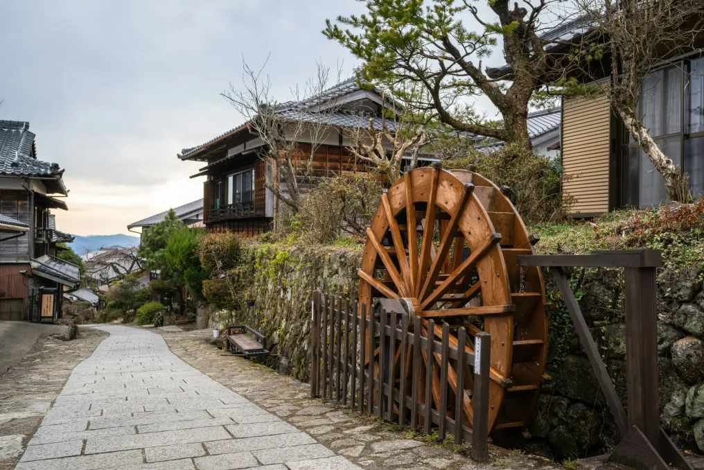
Unlike the coastal Tōkaidō route, Nakasendo traversed the mountainous interior of Honshu. Several historical sections remain in the Kiso Valley, including the former post towns of Magome, Tsumago, and Narai. The 8 km route between Magome-juku and Tsumago-juku is considered one of the most popular sections of Nakasendo. The hike takes about three hours at a leisurely pace and is suitable for most reasonably fit hikers.

The route passes through forests, agricultural fields, and small settlements, while Otaki and Metaki waterfalls offer stopping points. Traditional tea houses also provide pleasant breaks. The trail is marked in English and Japanese, although some sections briefly follow modern roads. When traveling with luggage, visitors can arrange delivery between villages through their tourist information centers; this service is seasonal, so advance checking is advised.

For a more challenging trek, there is an 8.5 km section between Yabuhara and Narai that crosses the Torii Pass. It takes about two and a half hours and includes a steep ascent from Yabuhara. The former post towns are the main reason for exploring the Kiso Valley, as each one showcases a different perspective on communities that developed along this main artery.

Located in Gifu Prefecture, Magome is a popular starting point for the hike to Tsumago. Its historic main street is adorned with traditional buildings, shops, restaurants, and museums. This town is also the birthplace of Japanese novelist Shimazaki Tōson, and a museum dedicated to his life and work highlights his connection to the region.

In Nagano Prefecture, Tsumago is one of Japan's best-preserved post towns. Its preservation is largely due to local residents who began protecting the historic settlement in 1968, resisting modern development that affected many rural communities. Measures included restricting vehicle traffic on the main street during the day and concealing overhead power lines. Visitors can tour traditional inns, shops, and museums, including restored Hondzin and Wakihondzin, which once accommodated travelers depending on their status. Staying overnight is recommended for those wishing to spend more time exploring the village.

Further along Nakasendo, Narai was once one of the wealthiest post towns on the route. Known as 'Narai of a Thousand Houses,' its historic main street stretches for about one kilometer. The village is also famous for Kiso lacquerware—a traditional craft found in local workshops and shops. Narai is accessible by train and marks the end of the hike across the Torii Pass from Yabuhara.

Kiso-Fukushima offers another perspective on the history of this thoroughfare. One of the four major checkpoints, where officials monitored travelers and regulated movement during the Edo period, was located here. The restored Fukushima checkpoint now functions as a museum, providing insight into the control measures applied to travel at that time.

Suitable months for hiking the Nakasendo generally include April and May, as well as July through November. Spring and autumn are considered particularly popular, although autumn accommodation can book up quickly. June and early July are often accompanied by rain, and winter conditions can make the trails slippery.

Accommodation options include traditional Japanese inns known as ryokan and small family guesthouses called minshuku. Tsumago and Narai are good options for those who wish to stay in historic post towns, while Kiso-Fukushima offers more lodging choices. The Kiso Valley is accessible by public transport. From Tokyo or Kyoto, one can reach Nagoya and transfer to the JR Chuo line.

To travel to Magome, take the Nakatsugawa station and board a local bus. In Tsumago, you can arrive via Nagiso station, followed by a bus or taxi. Narai has its own railway station within walking distance of the historic town. Allow about three hours for the walk from Magome to Tsumago, not including time spent touring the villages. Bus services are limited, so check local schedules before traveling.

It is recommended to wear comfortable walking shoes, carry drinking water, and dress appropriately for the weather. Shops are scarce along forest sections, and parts of the trail pass through bear habitats. Follow local safety advice and use a bear bell if recommended.

Nakasendo allows travelers to step outside the major cities of Japan and experience the history of the communities situated along its old mountain road. From the popular Magome-Tsumago route to the preserved streets of Narai, the Kiso Valley is more than just a brief stop on a Japanese itinerary. For those interested in combining trekking and history, this is a route worth dedicating time to.

Similar stories

Naoshima Island in Japan has become an international center for contemporary art
Read more
getaway.co.za

Naoshima Island in Japan has become an international center for contemporary art

A small island in the Seto Inland Sea has gained a new identity through contemporary art. Naoshima's museums, unusual installations, and picturesque sea views now attract visitors from all over the world.

On the island, where fishing boats line the harbor and narrow streets are adorned with traditional houses, contemporary art has become an unexpected addition to the marine landscape. Covering an area of about eight square kilometers, the Japanese island has become a globally recognized cultural destination.

This transformation process began in the 1980s when publisher Tetsuhiko Fukutake and then-mayor Chikatsugu Miyake shared a common vision of integrating art, education, and nature. The first major development occurred in 1989 with the opening of the Naoshima International Camp, followed by the Benesse House Museum in 1992. In subsequent decades, the project grew into what is known today as the Benesse Art Site Naoshima.

Instead of simply building galleries, the goal was to integrate art directly into the island itself. Old houses, coastal areas, and the surrounding landscape became part of the overall experience. This new cultural identity developed parallel to Naoshima's long-standing copper smelting industry, which remains an important component of local life.

Japanese architect Tadao Ando played a significant role in shaping Naoshima's identity. His projects combine concrete, natural light, and geometric forms, often making the buildings as interesting as the exhibits inside them.

The Benesse House Museum, opened in 1992, combines museum and hotel functions, where artworks are displayed both inside and on the adjacent grounds. Another outstanding project by Ando is the Chichu Museum, opened in 2004. It is built predominantly underground to preserve the surrounding landscape and uses natural light to illuminate its exhibition halls.

The museum features permanent works by Claude Monet, James Turrell, and Walter De Maria. Among the main exhibits are five Monet paintings of 'Water Lilies,' as well as installations exploring perception, space, and light.

Some of Naoshima's most interesting art spaces are located among its residential streets. The 'Art House' project, launched in 1998, transformed vacant traditional buildings in the Honmura district into modern art spaces. There are now seven locations there, each with its unique artistic concept. Visitors can explore them on foot, moving between installations, past local homes and businesses.

For a more unconventional experience, there is the public bathhouse Naoshima Bat Ai Love, designed by artist Shinro Ohtake. Its colorful interiors transform the ordinary Japanese experience into an extraordinary artistic event.

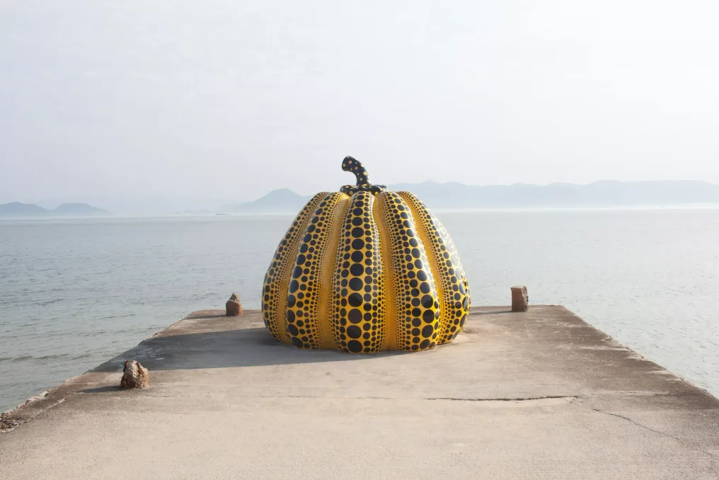
The pumpkins are also worth mentioning. Yayoi Kusama's Yellow Pumpkin stands by the sea near Benesse House, and the Red Pumpkin is located near Miyanoura Port. Their bright colors and characteristic patterns have made them some of the island's most recognizable attractions.

Naoshima's art scene continues to evolve. On May 31, 2025, the New Museum of Art Naoshima opened near Honmura. It was also designed by Tadao Ando and focuses on contemporary art from Japan and wider Asia, adding another dimension to the island's cultural offering.

The island is also part of a broader art route in the Seto Inland Sea. Nearby are Teshima and Inujima, which have their own museums and installations, making the entire region worth exploring beyond Naoshima.

Ferry services connect Naoshima with Uno Port in Okayama Prefecture and Takamatsu in Kagawa Prefecture. The journey to Miyanoura Port takes about 20 minutes from Uno and 50 to 60 minutes from Takamatsu.

Upon arrival on the island, visitors can use local buses, rent bicycles, or explore on foot. Since the attractions are spread across different areas, it is recommended to allocate more than a few hours for a visit. Some museums and art spaces require advance online booking, including timed tickets for the Chichu Museum and selected Art House project installations. Before traveling, check the official Benesse Art Site calendar, as operating days and entry conditions vary.

Overnight stays are also available: Benesse House offers accommodation within its complex, while guesthouses and other options are located in other parts of the island.

The transformation of Naoshima serves as a reminder of how art can give a place a new identity without erasing its distinctive features. Between the museums and installations remain the fishing boats, quiet streets, and rhythms of everyday island life. Industrial history and the contemporary art scene coexist, giving the island a unique character.

Gorongosa National Park Restores Wildlife and Supports Local Communities in Mozambique
Read more
getaway.co.za

Gorongosa National Park Restores Wildlife and Supports Local Communities in Mozambique

A significant conservation initiative is underway in central Mozambique, transforming a landscape previously scarred by war into one of Africa's most inspiring wildlife recovery stories.

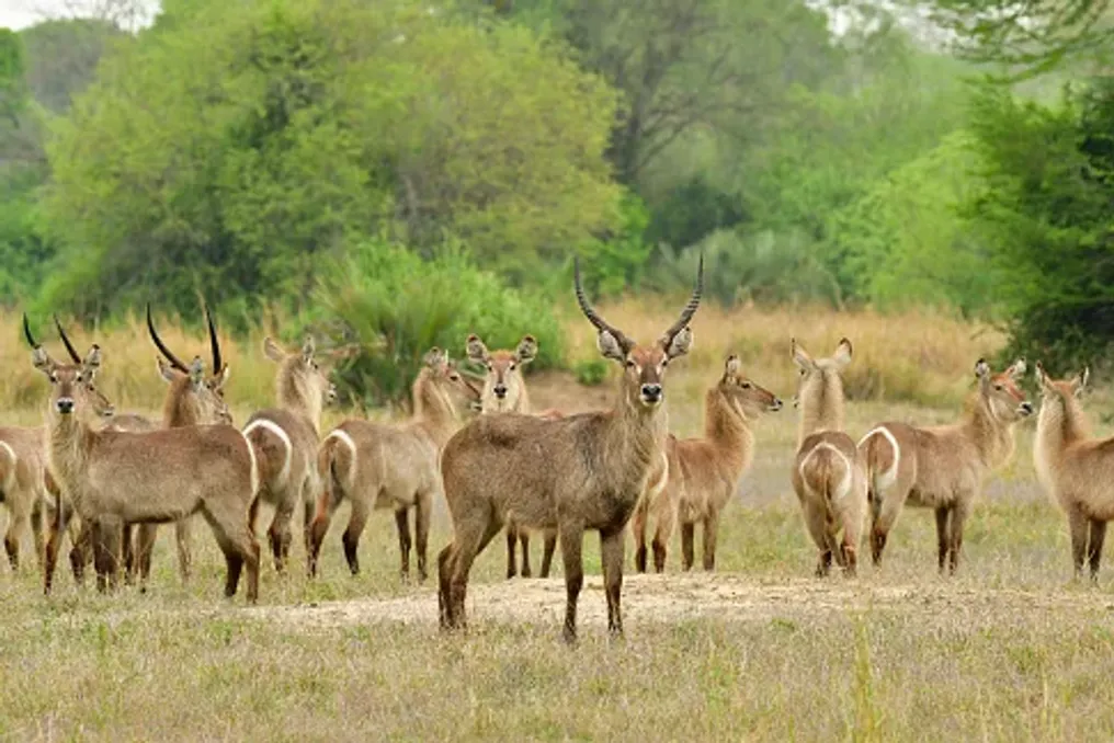
In Gorongosa National Park, elephants roam freely, lions move across the savanna, and researchers study the exceptional biodiversity of nearby mountain forests. However, the park's revival goes beyond simply bringing back animals; it also involves ecosystem restoration, supporting local livelihoods, and demonstrating the dependence of future conservation on the people living alongside wildlife.

Established in 1960, Gorongosa National Park is located in Sofala Province, Mozambique, at the southern end of the Great Rift Valley. Its territory encompasses open grasslands, forested savanna, seasonal wetlands, rivers, and mountain habitats, forming a mosaic of environments that supports a vast diversity of wildlife. For a long time, the park was considered one of Africa's premier safari destinations.

This reputation was undermined during the Mozambican civil war, which lasted from 1977 to 1992. Wildlife populations suffered massive losses due to poaching for meat and ivory, and the conflict disrupted park protection and management. In the following years, the task was not only to restore a renowned safari destination but also to reconstruct an ecosystem whose natural balance had been severely disturbed.

The restoration began gaining momentum in the early 2000s with the Gorongosa Restoration Project, which laid the foundation for long-term rehabilitation. In 2008, the Government of Mozambique and the Carr Foundation established a public-private partnership focused on biodiversity and ecotourism conservation, as well as human development in surrounding communities. This agreement was extended for another 25 years in 2018.

The approach recognized that a functioning national park requires more than just protected boundaries. Animals need healthy habitats, rangers need resources for protection, and neighboring communities must have opportunities to benefit from a thriving natural environment.

The restoration of Gorongosa's fauna required years of work in monitoring, habitat management, anti-poaching efforts, and carefully planned animal reintroductions. The goal is not merely to increase animal numbers but to create a functioning ecosystem where various species can perform their ecological roles.

Large herbivores, such as elephants, buffalo, and zebras, influence the landscape through grazing, vegetation consumption, seed dispersal, and movement across biotopes. Predators, in turn, help regulate prey populations and contribute to complex relationships that shape the ecosystem.

Restoration efforts included the return of species such as African wild dogs, also known as painted wolves, as well as zebras, hyenas, and leopards. These efforts are supported by veterinary teams, wildlife monitoring, and constant protection.

The results are measurable. According to the Gorongosa Restoration Project report for 2024, aerial surveys counted 110,513 large animals within the national park, the highest figure recorded by the project to date. The same report documented the translocation of seven hyenas, 32 zebras, and two leopards during the year.

These figures provide an encouraging snapshot of the recovery, although population counts alone are not enough to tell the whole story. Long-term success also depends on habitat quality, species diversity, genetic health, and the ability of wildlife populations to withstand future environmental threats.

Wildlife recovery depends on the people working behind the scenes. The Gorongosa Department of Wildlife employs rangers and specialists responsible for law enforcement, animal management, reintroductions, and human-wildlife coexistence. Official department information states that over 300 people work there, with the workforce predominantly from Mozambique.

Their activities range from wildlife observation and emergency response to preventing poaching and assisting in managing human-wildlife encounters.

For visitors, the result can be a memorable sighting of elephants crossing a floodplain or a predator resting in the shade. Behind these moments is a sustained effort to protect the conditions that allow wildlife to survive.

More Than Just the Park's Savanna and Floodplains

Beyond the park's more famous savannas and floodplains, there is another world. Mount Gorongosa rises above the surrounding landscape, supporting tropical forest, mountain grasslands, and diverse habitats, making the broader Gorongosa ecosystem particularly vital for biodiversity.

The mountain is not just a picturesque backdrop for safaris on the plains below. Its forests play a crucial role in regional water supply systems, and its diverse habitats provide homes for plants and animals that might be overlooked in the more conventional narrative of African megafauna.

The montane forests collect and regulate water, helping to sustain the streams and rivers that feed the surrounding landscape. Rivers originating on Mount Gorongosa are especially important for the national park's floodplains and the wildlife dependent upon them.

However, these forests face pressure from deforestation and loss of natural vegetation. Protecting them requires a holistic approach that considers the entire landscape: from mountain slopes and agricultural lands to rivers and wetlands. Thus, forest restoration is closely linked to the future of the savanna below.

Damage to the mountain watersheds can affect water availability and habitat health throughout the wider ecosystem.

Gorongosa has also become an important center for ecological research. Its scientific program supports the study of biodiversity, animal behavior, ecology, and long-term ecosystem restoration. Researchers use wildlife observations, field studies, and other monitoring methods to understand how species and habitats respond to conservation measures. The park's scientific work also provides opportunities for student training and the development of expertise in nature conservation in Mozambique.

This research helps answer practical questions: How do large herbivores impact vegetation? How does fire shape the savanna? Which habitats require urgent protection? And how can conservation managers determine if interventions yield long-term results? The answers help inform local decisions, turning Gorongosa into a living laboratory where restoration can be studied and improved over time.

One of the most significant aspects of the Gorongosa approach is the recognition that wildlife cannot be protected in isolation from the lives of people in the surrounding region. Communities living near protected areas depend on the land for sustenance, income, and natural resources. When conservation restricts access to resources without offering viable alternatives, it can create tension. However, when it creates opportunities and improves livelihoods, local residents can become active partners in environmental protection.

Thus, the Gorongosa restoration program extends beyond park boundaries, incorporating initiatives in agriculture, education, healthcare, and sustainable development. A prime example is the coffee cultivation program on Mount Gorongosa. Launched in 2014, this initiative introduced Arabica grown under local shade trees. This agroforestry approach offers farmers a commercial crop while helping to restore tree cover and reduce pressure on deforestation for agriculture. The coffee is processed locally and sold in Mozambican and international markets.

The model links environmental restoration with household income. Instead of viewing agriculture and forest conservation as competing priorities, it seeks to make them mutually supportive. The program has expanded significantly. According to official Gorongosa product information, over 1,600 farmers cultivate coffee on an area exceeding 500 hectares. A broader agricultural portfolio also includes honey, chili, and cashew, creating additional opportunities for producers in communities around the park.

These enterprises are important because conservation must be economically viable for the people whose daily decisions affect the landscape. A farmer who can earn income from a shaded crop has a practical incentive to help preserve the trees that support it. Although farmers still face challenges related to weather, markets, transport, and production costs, this demonstrates how carefully designed agricultural programs can promote both rural development and environmental restoration.

Gorongosa's programs for local communities also address needs beyond farming. The restoration project supports educational initiatives, medical services, and youth opportunities, recognizing that healthy communities are an integral part of a sustainable conservation landscape. Education can help youth develop skills and explore future professions, including science, tourism, and conservation. Health initiatives can improve access to basic services in rural areas, while agricultural support can help households strengthen food security and income.

These programs are not separate from the park's ecological mission. They are part of a broader strategy where biodiversity protection and human well-being improvement are viewed as interconnected goals. This link is particularly crucial in the Gorongosa mountain area, where forest protection must consider the needs of people living and farming on its slopes. Long-term success depends on finding ways for communities to benefit from healthy landscapes without depleting the resources they depend on.

For travelers, Gorongosa offers a chance to witness the history of conservation unfolding in real time. The park's appeal lies in the diversity of landscapes and activities: from wildlife viewing on open plains to exploring the mountain environment and learning about conservation work. The park's savannas and seasonal wetlands serve as habitats for elephants, lions, buffalo, hippos, zebras, and many other species. Lake Urema and its surrounding floodplains are defining features of the landscape, changing with the seasons as water levels rise and fall.

Guided tours allow visitors to observe wildlife while learning about the interconnections between animals, vegetation, and water. Birdwatching is another attraction, as the park's diverse habitats support rich avian diversity. Wildlife sightings are not guaranteed, and the experience depends on factors such as season, rainfall, and animal movements. This unpredictability is part of what distinguishes visiting functioning wildlife from a mere attraction.

The Gorongosa Mountains offer a contrasting experience to the open plains. Visitors can explore mountainous terrain, forested slopes, and waterfalls, including Murumbodzi Waterfall, located in the mountain landscape. Hiking and other activities should be organized through authorized park operators, with access depending on conditions and current visitor plans. This side of Gorongosa is particularly valuable for travelers interested in plants, landscapes, and conservation outside of traditional safari. It also provides insight into the ecological links between the montane forests and the rich lowlands. The Gorongosa restoration work adds an extra dimension to the visit. Tourism can help generate income for conservation and local livelihoods, and tours offer opportunities to learn about the park's ecological and social programs. Official visitor information describes accommodation options and available activities. Travelers should check current access conditions and seasonal specifics.
Derinkuyu Underground City in Cappadocia: A Hidden Settlement Beneath Volcanic Landscapes
Read more
getaway.co.za

Derinkuyu Underground City in Cappadocia: A Hidden Settlement Beneath Volcanic Landscapes

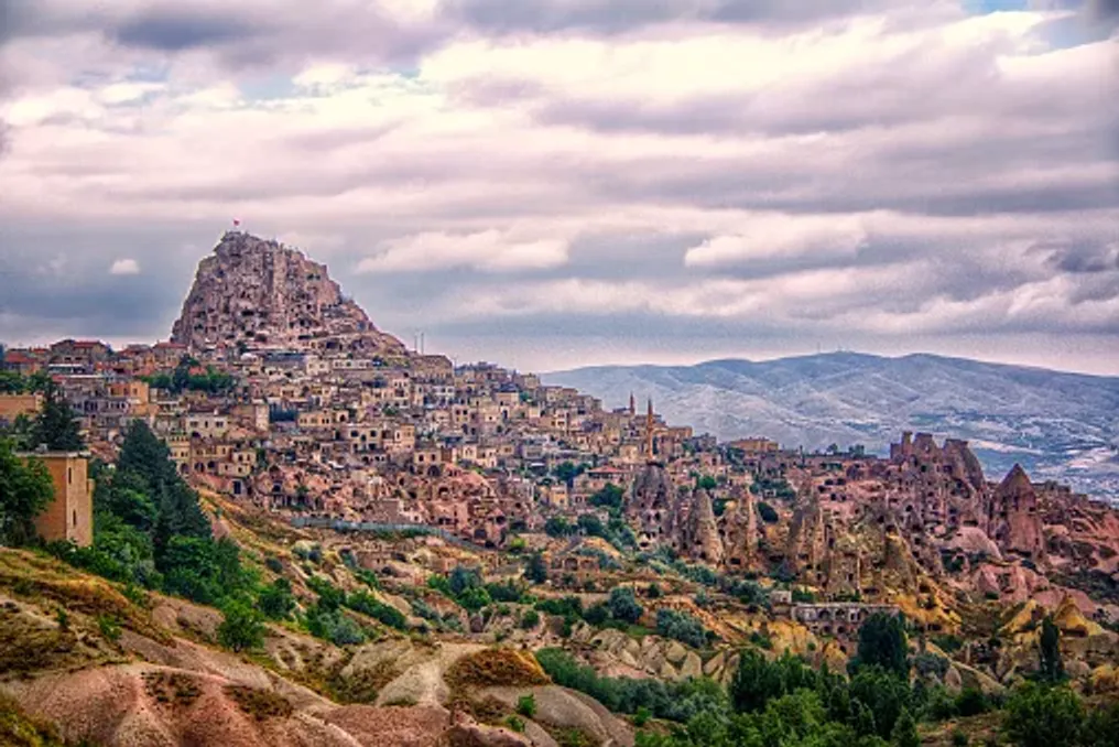
Located amidst the characteristic volcanic landscapes of central Turkey is an outstanding settlement that elevates the concept of life on Earth to a new level. The underground city of Derinkuyu descends deep into the earth, revealing a network of narrow tunnels, rooms carved into the rock, storage areas, and ventilation shafts excavated from the region's soft volcanic rock.

The unusual topography of Cappadocia is largely due to ancient volcanic activity. Eruptions in the surrounding area covered the landscape with ash, which over time hardened into a relatively soft rock known as tuff. Over time, erosion formed the region's characteristic valleys, pillars, and fairy chimneys, and the rock itself provided accessible material for constructing homes, churches, and underground spaces.

For the communities settled here, this geology allowed them to build not only on the surface. Instead of constructing everything from stone or wood, people could excavate rooms directly into the rock, gradually creating interconnected spaces beneath their settlements.

Derinkuyu is among the largest and deepest underground complexes in Cappadocia. The Turkish Ministry of Culture and Tourism records a depth of about 85 meters, although only a portion of this vast complex is accessible to visitors today.

This underground city is part of a wider network of subterranean settlements throughout Cappadocia, where underground architecture became an important response to environmental conditions and periods of instability in the region. Derinkuyu was not merely a labyrinth of escape tunnels; its chambers demonstrate the practical needs of a community that required shelter underground for extended periods.

Functionality and Religious Significance

The excavated spaces include stables, cellars, food storage areas, kitchens, communal areas, and religious sites. Among the features identified by Turkish museum authorities is a missionary school, and the church, baptismal area, and other religious structures reflect the significance of Christianity in the settlement's history.

The location of these areas indicates that the underground city was designed to support daily activities as well as emergencies. Animals could be kept in designated areas, food and supplies stored, and communal areas allowed people to gather away from the open landscape above.

The construction also reflects a practical understanding of movement: stables and other functional rooms were located on upper levels, facilitating the descent of animals underground. Kitchens and storage areas were similarly organized to ensure the transport of food and other necessities.

Although popular accounts sometimes describe Derinkuyu as a city where thousands of people could live underground for months, the exact capacity and circumstances of its use remain difficult to establish. It is clear only that its scale and amenities made it significantly more complex than just a refuge.

Ventilation System and Safety

One of the most impressive elements of Derinkuyu is its ventilation system. The main shaft extends to the surface, helping to circulate air through the underground levels. This system was vital in the complex structure, where closed chambers and narrow passages could otherwise become uninhabitable for long stays.

The main ventilation shaft also served as a well. Access to water would have been critically important for anyone sheltering underground, especially when exiting the settlement was unsafe. Turkish museum information describes a shaft approximately 55 meters deep, connecting to the surface and serving this dual function.

The broader network includes numerous passages and shafts, although the exact location and number of ventilation openings vary in published sources. All these elements demonstrate how the settlement builders managed the challenges of living underground.

Safety was also a central concern. Large circular stone doors were installed at strategic points along some passages. These heavy barriers could be sealed from the inside, helping residents block access to sections of the settlement when a threat arose.

The tunnels themselves were often narrow, with some passages allowing only one person to pass at a time. While such planning may complicate navigation through the complex today, it also helped restrict movement within it. The combination of hidden entrances, winding corridors, and defensive barriers created a network where access could be controlled. Instead of relying on a single fortified wall, the underground city utilized its layout and surrounding rock for defense.

History and Discovery

The exact origin of Derinkuyu remains uncertain. Some accounts date the earliest phases of Cappadocia's underground settlements to antiquity, while later communities expanded and adapted them over many centuries. Therefore, it is more accurate to understand Derinkuyu as a place shaped by successive generations, rather than a city built in a single period.

Christian communities played an important role in the region's underground history. UNESCO notes that the rock-cut settlements and underground cities of Cappadocia, including Derinkuyu and nearby Kaymakli, served as a refuge during Arab invasions into Byzantine territory. These underground spaces provided protection from raids and other threats, allowing residents to hide with provisions and, if necessary, livestock. Their use was not necessarily continuous: people could enter the underground complex when circumstances demanded and return to surface settlements when it became safe.

The religious spaces of the settlement provide additional evidence about the communities that used and adapted them. However, the history is more complex than a single narrative of persecution or one group of builders. The development of Derinkuyu reflects the changing needs of people living in a region that experienced shifts in political, cultural, and religious views.

For centuries, parts of Cappadocia's underground world remained unnoticed. Derinkuyu came to the attention of modern times in 1963 when a local resident reportedly discovered a hidden room during home renovations. Subsequent investigation revealed that this chamber was connected to a much larger underground network. This discovery drew attention to the scale of the underground settlement and the volume of preserved architecture. The site was subsequently excavated and opened to visitors in the 1960s.

Today, only a portion of Derinkuyu is available to the public. According to Turkish museum authorities, about 10% of the underground city is open to visitors, giving an idea of a complex that extends far beyond the areas explored during a typical tour.

Its rediscovery also highlights how much of Cappadocia's history is preserved beneath the modern landscape. The region's archaeological heritage is not limited to structures visible from its valleys and roads; it is also within the rock itself.

Visiting Derinkuyu offers a completely different experience compared to exploring Cappadocia's open valleys and viewpoints. The route leads through dimly lit chambers, gentle passages, and stairs descending into the rock. Along the way, visitors can see evidence of the settlement's organization, including narrow corridors, storage rooms, and characteristic stone barriers.

The atmosphere is part of the experience. The temperature, limited light, and enclosed space create a sharp contrast with the bright, open landscapes above ground. Viewing a passage or descending into a shaft also provides insight into the labor involved in carving and maintaining such a vast network by hand.

This experience is not suitable for everyone. Some tunnels are narrow and steep, and visitors who are uncomfortable in confined spaces or have limited mobility may find certain parts of the route challenging. Those who visit should follow marked routes and any instructions from site personnel.

Derinkuyu is located in the Nevşehir province, approximately 30 kilometers from the town of Nevşehir. It can be combined with visits to other Cappadocia attractions, including rock-cut churches, cave dwellings, and characteristic volcanic landscapes.

Derinkuyu reminds us that some of the most remarkable architectural achievements were not created to dominate the landscape, but to merge with it. Its interconnected chambers, ventilation shafts, and defensive passages show how communities transformed soft volcanic rock into a place capable of providing shelter, storing supplies, and supporting daily life.

The underground city also serves as a reminder of the uncertainty surrounding much of the past. Its exact origins, full scope, and settlement patterns continue to be subjects of research, while the preserved spaces offer tangible proof of the ingenuity required for life beneath the surface.

For travelers exploring Cappadocia, Derinkuyu adds another dimension to the region celebrated for its extraordinary beauty. Beneath the fairy chimneys and cave hills lies a world shaped by geology, ingenuity, and the enduring human need for security.

Popular