Brazilian holiday to be marked by heat and rains in various regions of the country
Read more
Olhar Digital
olhardigital.com.br

Brazilian holiday to be marked by heat and rains in various regions of the country

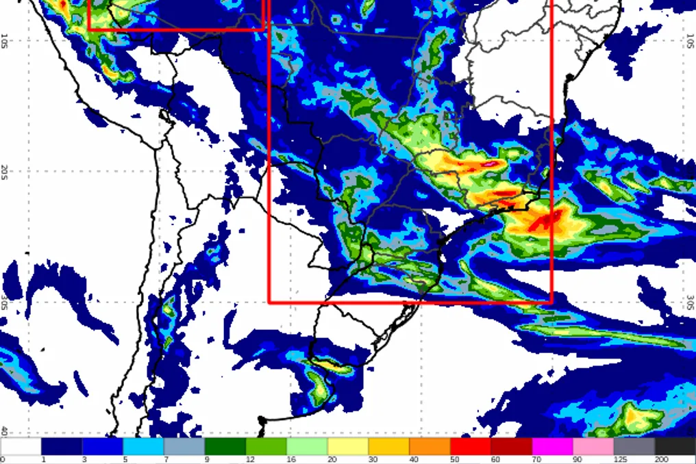
The last weekend of October will feature rain in several regions of Brazil, including Southeast, Midwest, North, and parts of the South, with a chance of storms and hail in certain locations.

On Monday, the 2nd, All Souls' Day holiday, temperatures are expected to rise across most of the national territory. The combination of high temperature and humidity will result in a muggy feeling, even during rain showers.

Between Friday, the 30th, and Saturday, the 31st, unstable conditions will mainly affect the Southeast and Midwest, extending to the North and South. Showers accompanied by thunderstorms and the possibility of heavy rain are forecast.

This Friday, all states in the Midwest received a yellow alert for potential danger due to heavy rains. In the Southeast, precipitation will reach almost the entire region, although temperatures will remain more moderate.

Rains will reach areas such as Maranhão, Piauí, Tocantins, and Bahia. In the North region, the most impacted areas are Amazonas, Acre, Rondônia, and southern Pará. In contrast, the weather will remain more stable and hot in most of the Northeast, Amapá, northern Pará, and eastern Roraima.

On Sunday, November 1st, rain will persist in Amazonas, in areas of Acre and Rondônia, in addition to covering the Midwest, Southeast, and northern South Region. In parts of Minas Gerais, Goiás, and Mato Grosso do Sul, there is a possibility of storms, and in areas of Minas Gerais and southern Mato Grosso do Sul, hail cannot be ruled out.

In Paraná, instabilities will increase in the north, northwest, and west of the state, with a risk of hail in northwestern Paraná. West Santa Catarina is also under a yellow alert for potential danger from storms. On the other hand, most of Rio Grande do Sul will have stable and sunny weather.

In the Northeast, heat and dry climate will continue to dominate, with a forecast maximum of 38°C in Teresina. On Monday, the 2nd, the heat will intensify in practically all regions. Even with the presence of clouds and rain, humidity will contribute to the muggy feeling.

In the South Region, instability will grow, with chances of rain in all three states. The same scenario applies to areas of the Southeast, where maximums can reach 30°C in Rio de Janeiro. In the Midwest, the intensity of the rain will decrease, but the heat will remain present.

The action of low-pressure systems over the interior of South America should intensify instabilities in the south-central part of the country. Furthermore, a corridor of humidity extending from the North to the Midwest and Southeast, reaching the north of the South Region, favors the occurrence of isolated rain showers and thunderstorms.


Similar stories

Weather forecast in São Paulo indicates heat up to 32°C before rain and temperature drop on Friday
Read more
viagemeturismo.abril.com.br

Weather forecast in São Paulo indicates heat up to 32°C before rain and temperature drop on Friday

São Paulo will face a sequence of hot days, with maximum temperatures potentially reaching 32°C on Wednesday, the 4th. This intense heat is associated with the formation of rain showers during the afternoons, with potential for thunderstorms.

On Thursday, the 5th, rain is expected at various times throughout the day. On Friday, the 6th, a significant reduction in maximum temperature is expected, dropping to 23°C.

Meteorological Alerts

INMET issued a yellow storm warning for the capital of São Paulo during Tuesday and Wednesday. This alert forecasts the possibility of intense precipitation, ranging between 20 to 30mm per hour or up to 50mm throughout the day, accompanied by strong winds of 40 to 60km/h and hail risk.

Details by Day

On Tuesday, November 3rd, the day will start with sun interspersed with clouds, and there will be rain showers in the afternoon. At night, the weather is expected to become clearer. Temperatures will range between 18°C and 31°C, with a 77% probability of rain.

On Wednesday, November 4th, the heat will increase, allowing the maximum to reach 32°C. The day will start sunny with an increase in cloud cover, followed by rain in the afternoon. The minimum predicted is 19°C, and the chance of rain is 69%.

For Thursday, November 5th, the sky will show periods of sun between clouds, but there is a forecast of sporadic rain both during the day and at night. Thermometers will register temperatures between 21°C and 28°C, with a high probability of rain of 93%.

Finally, on Friday, November 6th, the temperature will decrease, with a maximum of 23°C and a minimum of 18°C. The sky will remain cloudy throughout the day, and precipitation may occur at certain times, mainly at night, with a 90% probability of rain.

Showers advance across Brazil, bringing risk of thunderstorms in five regions
Read more
olhardigital.com.br

Showers advance across Brazil, bringing risk of thunderstorms in five regions

Forecasts indicate that several areas of Brazil will receive rain this Wednesday, the 28th, and Thursday, the 29th. The climatic instability also extends to the Southeast and South regions, presenting a risk of thunderstorms in certain locations.

In the MATOPIBA region, which includes parts of the states of Maranhão, Tocantins, Piauí, and Bahia, rain is predicted. In contrast, the heat remains intense in the far North and parts of the Northeast, with temperatures close to 40 °C.

Precipitation in the North Region is mainly concentrated in Acre, Amazonas, Rondônia, Pará, and Tocantins. The Center-West is also expected to register rain throughout almost its entire extent on Wednesday, with greater intensity expected for Mato Grosso, Mato Grosso do Sul, and Goiás the following day.

In the Southeast, instability strengthens in areas of São Paulo and Minas Gerais, with the possibility of rain also in Rio de Janeiro and Espírito Santo. For Thursday, rains resume advancing through the South, especially in Paraná. Furthermore, the Baian Recôncavo is under monitoring due to the expectation of heavy rainfall.

This change in climate pattern is attributed to the displacement of a high-pressure area towards the Atlantic Ocean. This movement allows warm and humid air to advance over the south-central part of the country, which favors the formation of instability zones.

Among the most notable points of the forecast, despite the rain in part of the national territory, the heat will remain present in the North and Northeast regions. Boa Vista (RR) may reach a maximum of 38 °C on both days, while in Teresina (PI), thermometers may reach 39 °C, even with rain forecast in some areas of the state.

In the Center-West, temperatures tend to be milder. In Cuiabá (MT), the maximum will drop from 34 °C on Wednesday to 30 °C on Thursday. In Brasília (DF), the projected highs are 27 °C and 28 °C, respectively.

In the São Paulo capital, the maximum will not exceed 20 °C on Wednesday and will drop to only 18 °C on Thursday. In Rio de Janeiro, temperatures are expected to reach 27 °C and 26 °C, respectively.

Cold will also be a relevant factor in the South. On Thursday, Curitiba (PR) will have temperatures ranging between 12 °C and 15 °C, and in Florianópolis (SC), the forecast points to a variation between 16 °C and 20 °C.

Yellow warnings for potential storms cover areas in several regions. In the Center-West, the alert is valid for the entire region during the two days. On Thursday, it extends to Paraná, Santa Catarina, and northern Rio Grande do Sul. In the Baian Recôncavo, the specific warning refers to the risk of significant rainfall accumulation.

Until the end of Thursday, the possibility of rain remains in the North, Center-West, Southeast, MATOPIBA, and South regions. However, in parts of the North and Northeast, dry weather and high temperatures are expected to persist.

Storms advance across Brazil, affecting Center-West, Southeast, and South, according to forecast
Read more
olhardigital.com.br

Storms advance across Brazil, affecting Center-West, Southeast, and South, according to forecast

Intense rains are spreading across parts of the Center-West, Southeast, and South this Thursday, the 22nd, and are expected to continue on Friday, the 23rd. There is an expectation of showers, thunderstorms, and risk of storms in these areas.

While instability moves across the national territory, the North and Northeast regions remain under the predominance of heat. The National Institute of Meteorology (Inmet) is monitoring the possible formation of an extratropical cyclone between Rio Grande do Sul and Uruguay.

Precipitation is expected to reach a vast area extending from Amazonas to Rio Grande do Sul, also covering Mato Grosso, Mato Grosso do Sul, and São Paulo. How the intensity and distribution of the rains occur will vary depending on the location.

On Thursday, yellow warnings were issued indicating potential danger of storms in areas of the North, Center-West, Southeast, and South regions. For Friday, the alert level will be raised to orange in parts of Paraná, Santa Catarina, and Rio Grande do Sul, as well as in southern Mato Grosso do Sul.

The forecast for Friday also points to the chance of a low-pressure area forming in eastern Argentina. This system tends to move towards the Atlantic Ocean, potentially generating an extratropical cyclone between the coast of Rio Grande do Sul and Uruguay.

The formation of this extratropical cyclone off the coast of Rio Grande do Sul and Uruguay may intensify instability in the South Region starting Friday (23rd), with impacts being felt mainly on Saturday.

Heat remains strong in various parts of the country. In Teresina, the maximum temperature forecast is 39°C for both Thursday and Friday. In Palmas, thermometers may reach 38°C on Friday, and Cuiabá is expected to record 36°C on both days.

In the Southeast, the greater cloud cover and occurrence of rain help moderate temperatures. São Paulo has a forecasted maximum of 25°C on Thursday and 24°C on Friday. In Rio de Janeiro, the maximum may reach 27°C on Friday, equaled by Vitória. In Belo Horizonte, the expected maximum is 26°C.

In the South Region, Curitiba will face a more noticeable reduction in temperatures: the forecast for Friday indicates a minimum of 15°C and a maximum of only 16°C.

Despite the heat in the interior of the Northeast, low humidity requires special attention. There are yellow warnings related to this risk in areas of Maranhão, Piauí, Ceará, Rio Grande do Norte, Paraíba, Pernambuco, and Bahia.

Popular