Marble Caves of Chile: How Water Shaped the Patagonian Stone Landscape
Read more
Getaway
getaway.co.za

Marble Caves of Chile: How Water Shaped the Patagonian Stone Landscape

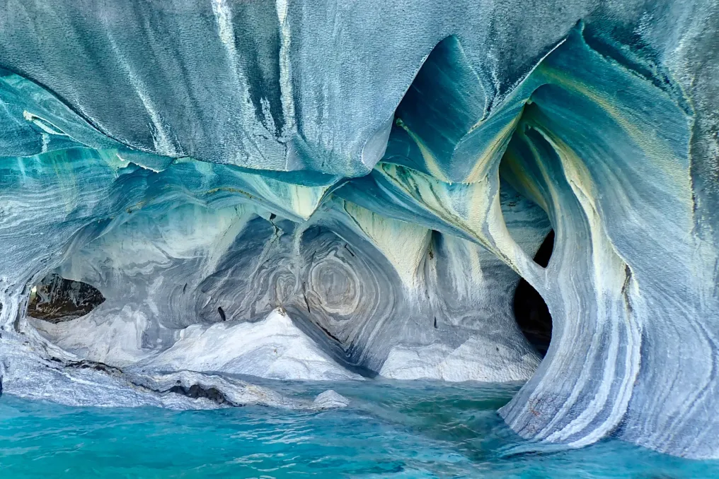
In Patagonia, Chile, ancient marble rises above turquoise water, forming wide curves, arches, and caves. Although the walls look as if they were carved by hand, their intricate pattern is the result of water working over millennia to gradually shape this stone world.

These unusual formations, known as Marble Caves or Capillas de Mármol, are located on the shores of Lake General Carrera in the Aysén region of Chile. They are best explored by boat or kayak, as they demonstrate the interaction of geology, water, and time.

The Marble Caves are near Lake General Carrera, a vast body of water shared between Chile and Argentina. On the Chilean side, visitors can see the Marble Cathedral, the Marble Chapel, and the Marble Cave, named for their high arches and vaulted forms.

The beauty of these places begins with the stone itself. The marble formed from limestone, which was subjected to heat and pressure deep within the Earth. It later ended up along the lake's shoreline, where waves gradually eroded the rock, creating the visible indentations, channels, and curved walls seen today.

The stone surface is adorned with bands of white, gray, and pink colors, while the lake reflects these sculpted surfaces in shades of blue and green. The color palette changes depending on the lighting, causing the caves to look different from various angles.

Lake General Carrera covers an area of about 1,850 square kilometers and is the largest lake in Chile. Its striking blue-green color is partly due to fine mineral particles carried by glacial meltwater, which scatter sunlight.

When sunlight reaches the caves, the water reflects off the pale gray marble, intensifying the colors. This results in a constantly changing landscape, shaped by light as much as by stone.

The nearest village of Puerto Río Tranquilo serves as the main starting point for organized boat and kayak tours. From here, visitors cross the lake to view the formations from the water. Boat tours offer a convenient way to see the caves, while kayaking provides a closer perspective, allowing visitors to pass through narrow openings under safe conditions. Accessibility depends on the weather, as wind conditions and water levels can affect tours.

Inside the caves, the curved marble walls frame views of the turquoise water and daylight. One should pause for a moment to appreciate the scale and detail of the stone.

The Marble Caves are located along the Carretera Austral in Chile, a scenic route through Patagonia. These caves were declared a nature reserve in 1994. Visitors are advised to follow the guides' instructions and avoid touching or marking the marble, helping to protect formations that have been shaped over thousands of years.

The Marble Caves serve as proof that nature does not need to act quickly to create something exceptional. Over millennia, water has carved ancient stone into arches and caves, leaving behind a landscape that changes with every reflection. In a region known for its glaciers and mountains, this is a unique Patagonian wonder. The magnificence lies not in reaching the summit, but in gliding beneath the sculpted rocks and watching the turquoise water catch the light. Here, time is captured in stone, and every wave adds a chapter to this story.

Similar stories

Focus on Latin America: Architecture, Housing, Memory, and Cultural Exchange Highlighted This Month
Read more
archdaily.com.br

Focus on Latin America: Architecture, Housing, Memory, and Cultural Exchange Highlighted This Month

Architecture in Latin America during this period reflects a constant dialogue about the issue of dwelling, cultural heritage, and the ways in which architecture can connect current life with established knowledge and places. From the International Architecture Biennial in Buenos Aires and initiatives focused on traditional construction methods and archaeological heritage, to new cultural infrastructures and housing developments in Argentina, Ecuador, and Peru, recent developments point to diverse methodologies for working with regional contexts. Across the area, themes such as memory, community, landscape, and material practice continue to influence both architectural projects and broader conversations about how cities and territories are occupied.

Urban Life: Biennials, Heritage, and Cultural Memory

The International Architecture Biennial of Buenos Aires is celebrating its 40th anniversary with its 20th edition, gathering approximately 100 architectural firms, 15 exhibitions, 50 conferences, and 40 international participants from over 55 cities. With free programming from September 22nd through October, as part of Buenos Aires' Design and Architecture Month, the event centers on the theme HABITAT, investigating the connection between individuals, architecture, cities, territories, and communities. The main exhibition, held at the National Museum of Fine Arts, is complemented by shows covering various subjects, from Antarctica and nature to the work of César Pelli and Diana Balmori, in addition to a cultural circuit throughout the metropolis.

The focus on habitat is also manifested in actions in other regions that treat heritage as living knowledge. In Valparaíso, Chile, the 'Oficios en Obra' meeting will bring together master craftsmen, industry professionals, educational institutions, heritage entities, and local communities between October 9th and 11th. The objective is to analyze ancient construction practices through workshops, demonstrations, debates, and heritage routes. This meeting covers the transmission of trades such as carpentry and rammed earth, alongside new technologies, sustainable construction, and conservation.

In Lima, meanwhile, Red Lima Milenaria is working to obtain UNESCO recognition for a group of pre-Columbian archaeological sites located within the modern city—including El Paraíso, Huaca Pucllana, the Campoy fortress, and sections of the Surco Canal—highlighting how historical sites persist in urban dynamics.

Cultural Institutions and Temporary Landscapes Expand Latin American Narratives

Cultural infrastructure is also changing in Buenos Aires, where MALBA announced an underground expansion, designed by Taller Frida Escobedo, as part of its 25-year program. This project, situated beneath Plaza República del Perú, will nearly double the museum's exhibition space, adding temporary galleries, an auditorium, multi-functional rooms, workshops, storage, offices, and a new patio square. By implementing the expansion under the park, the proposal maintains the existing public space while establishing new connections between the museum, the landscape, and adjacent avenues. This expansion is added to the recent inclusion of the Daros Latinamerica Collection and is scheduled to open in late 2029 or early 2030.

A distinct approach to the cultural agenda appears at Macondo Park, a ephemeral landscape designed by Bjarke Ingels Group (BIG), Komodo, and Vampire for Shakira's season in Madrid. Inspired by Gabriel García Márquez's fictional town of One Hundred Years of Solitude, the 185,000 square meter park surrounds the concert venue and extends the programming through areas dedicated to art, dance, gastronomy, literature, cinema, and fashion. Twelve thematic pavilions and a central plaza are interconnected by paths and over 500 trees, forming a transient cultural landscape parallel to the shows. The structures were assembled using light fabrics, modular scaffolding, and recyclable components, with initial planning for disassembly and reuse, while the trees will be returned to local nurseries after the season ends.

Featured Projects

Located in the Monkul swamp, Chile—a coastal ecosystem recognized by the Ramsar Convention—the Kay Kay Boardwalk and Viewpoint of Monkul, designed by Gonzalo Verdugo and Carlos Seguel Arquitectos, offers a low-impact wooden path. This allows visiting the public to experience the landscape while minimizing any interference with its delicate environment. The intervention, covering 1,110 square meters, follows the geography of the swamp through a yellowish and fully accessible boardwalk, equipped with three viewpoints containing scientific and cultural information. Developed in partnership with the Mateo Nahuelpan Community, the project dialogues with the ancestral territory and the Mapuche Lafquenche culture, while creating a succession of views, moments of pause, and meeting points. Its reversible construction and careful installation respect the existing landscape, uniting environmental interpretation, accessibility, and cultural heritage in a discreet intervention.

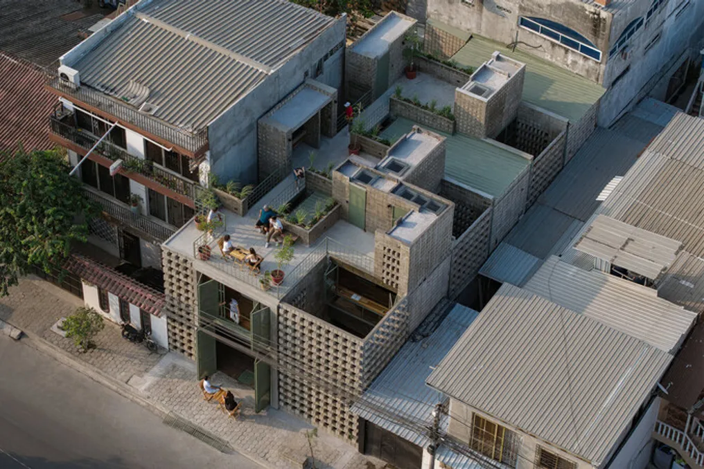
Situated in Durán, a satellite city of Guayaquil, Ecuador, the La Colmena project converts an old 70s residence into a housing complex consisting of three units, reconnecting housing with the neighboring neighborhood. Instead of occupying the entire 10 by 20 meter plot, the 335 square meter project preserves the original structure and incorporates six courtyards that filter rainwater and act as climatic corridors, improving ventilation and reducing internal temperatures in a city subject to seasonal flooding. A corridor planned as an extension of the sidewalk, shared terraces, gardens, and a cultural-gastronomic space further connect the houses to the street, generating places for meetings and productive activities. The use of local concrete blocks and wood, combined with traditional artisanal techniques, strengthens the project's link to its immediate surroundings.

Residencia KUSKA / Taller MACAA (Mission of Architecture, Construction, and Art in the Andes)

Located at an altitude of 3,100 meters near Cusco, the KUSKA Residence, by Taller MACAA, reformulates Andean construction traditions into a modern refuge intended for someone dedicated to writing and craftsmanship, while also hosting family, friends, and resident artists. The 400 square meter complex is organized into four interconnected volumes that form a sequence of patios, trails, galleries, and common areas, defining distinct relationships between private, communal, and surrounding landscapes. Built with 40-centimeter thick adobe walls on stone foundations, and covered with eucalyptus and reed, the building uses traditional materials to respond to the region's thermal variations. Additionally, solar energy systems, rainwater harvesting, biofilter, biodigester, and dry toilets allow the house to operate autonomously from conventional infrastructure.

Highlights Events

The XXX Colombian Biennial of Architecture and Urbanism, organized by the Colombian Society of Architects, will mark its 30th edition in 2026, continuing a biennial platform dedicated to recording and recognizing architecture produced in Colombia. This edition will expand its regional scope through the I Latin American Biennial of Architecture of Colombia, which will foster the dialogue of projects from all of Latin America with Colombian practice. In parallel, the VII Colombian Biennial of Architecture Students will highlight academic research and experimental projects by emerging architects. The biennial aims to provoke reflection on architecture in relation to its urban, historical, environmental, social, and cultural aspects, bringing together professionals, institutions, the academic community, and the general public.

Design Week Mexico will return from October 5th to 11th for its 18th edition, integrating architecture, design, craft, and art throughout Mexico City through exhibitions, creative residencies, installations, guided tours, and other public activities. The 2026 edition will feature Chile as Guest of Honor Country and the Middle East and North Africa as Guest Region, with events at locations such as Casa Ortega, National Museum of Anthropology, G.56 Creative Hub, Design House, Espacio CDMX, and Lincoln Park. As part of the program, ArchDaily will also promote the Next Practices Live in Mexico event at Design House on October 12th, gathering winners of the Next Practices Awards 2026 and former award-winning firms based in Mexico to debate the potential for transformation and action in architecture.
Lençóis Maranhenses: Brazilian landscape resembling a desert that fills with freshwater lakes
Read more
getaway.co.za

Lençóis Maranhenses: Brazilian landscape resembling a desert that fills with freshwater lakes

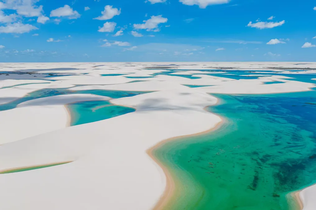
At a glance, Lençóis Maranhenses appears to be a desert that somehow ended up on the Atlantic coast of Brazil. Endless white dunes stretch to the horizon, interrupted only by bright blue and green lagoons.

However, there is an irony in this landscape: it is not a desert at all. Located in the state of Maranhão in northeastern Brazil, Lençóis Maranhenses is an extensive coastal landscape shaped by wind, rain, sand, and the Atlantic Ocean. During the rainy season, fresh water collects between the dunes, transforming the seemingly barren landscape into something almost otherworldly.

Water appears in this area for several months. The name Lençóis Maranhenses translates approximately to 'sheets,' which aptly describes the vast dunes undulating across the landscape. The national park covers an area of over 156,000 hectares, of which about 90,000 hectares are dunes. Some of these reach heights of about 30 meters, and the dune fields extend for tens of kilometers along the coast.

Nevertheless, calling it a desert is inaccurate. The region has a clearly defined rainy season, and abundant rainfall accumulates in the depressions between the dunes. As the groundwater level rises beneath the sand, hundreds of temporary freshwater lagoons begin to form. The result of this process is truly extraordinary: white sand runs everywhere, interspersed with bodies of clear, blue-green water.

These dunes are constantly moving. The wind carries sand from the coast inland, giving it characteristic crescent shapes that define the park's appearance. Some dunes can migrate more than 20 meters per year, slowly changing the surrounding landscape. The lagoons are also temporary; they fill mainly with rainwater and groundwater, not rivers. When the dry season arrives, evaporation causes many of them to shrink and disappear, after which the cycle resumes with the rains.

Perhaps the most fascinating thing about Lençóis Maranhenses is that the landscape visible today might look different next year. The dunes move, the water comes and goes, and nature quietly reshapes this scene.

Although the park looks almost desolate from a distance, a surprisingly diverse ecosystem hides beneath the endless expanse of sand. Lençóis Maranhenses is located at the junction of the Cerrado, Caatinga, and Amazon biomes, creating a mix of dunes, freshwater zones, mangrove swamps, rivers, and coastal habitats. Even the temporary lagoons support life, and the plants growing among the dunes have adapted to an environment where water and sand are constantly changing.

Despite the outward impression that nothing can survive here, the situation is quite the opposite. Among the main entry points to the park are Barreirinhas, Santo Amaro, and Atins. From Barreirinhas, visitors can reach some of the most famous lagoon areas, while Santo Amaro provides access to other parts of the dunes. Atins, once a small fishing village, is located near the mouth of the Preguiças River and has become another popular base for exploring the landscape.

For those wishing for a deeper immersion, the multi-day trek Travessia dos Lençóis crosses the park between Atins and Santo Amaro. This is a different way of experiencing the landscape: instead of simply arriving, taking photos, and leaving, tourists traverse the dunes, swim in the lagoons, and spend nights in the park using local community accommodations along the route.

For such a vast place, slowing down the pace seems the most suitable way to explore it. The landscape undergoes radical changes throughout the year. Lagoons usually reach their maximum volume after the rainy season, with May to September often offering some of the best conditions for observing them filled with water. Exact conditions vary depending on the amount of rainfall each year. By the end of the dry season, some lagoons may recede or completely disappear, and paradoxically, this makes the landscape even more attractive.

What is depicted in the photograph is just one moment in the life of Lençóis Maranhenses. The park was declared a national park in 1981 and was included in the UNESCO World Heritage List in 2024 due to its exceptional natural beauty and geological significance. The park is carefully managed, with visitor access and vehicle use regulated to protect the fragile dune and lagoon ecosystems.

The reason for such regulation is easy to understand. It is a landscape not created for stillness. It is shaped by rain and wind, constantly shifting underfoot and changing with the seasons. There is something wonderfully strange about Lençóis Maranhenses: a dry appearance is brought to life by rain, seemingly permanent dunes are constantly moving, and freshwater lagoons appear among the sand for a time and then vanish. Nothing here is as fixed as it first seems, and perhaps that is what makes this corner of Brazil so captivating. It is an unusual reminder that nature does not always follow our expectations.

Popular